Key Takeaway:
Malaysian Airlines Flight MH370 disappeared less than an hour after take-off in March 2014, leaving a massive mystery. The plane’s flight path was a mystery, with intermittent satellite location information suggesting it was flown south on a different path. The search involved over 300 flights, surface and submersible vehicle surveys, and was one of the most expensive aviation searches in history. Confirmed debris were found on Reunion Island and off the coast of Mozambique in 2015 and 2016, respectively. The search has been aided by experts and the public, with data analysis and lessons from past flight disasters. The development of advanced autonomous submersible vehicles may be key to finding MH370 in the Southern Indian Ocean.
It has been ten years since Malaysian airlines flight MH370, carrying 239 passengers and crew on board, disappeared less than one hour after taking off from Kuala Lumpur on 8 March 2014. It has become one of the great unsolved mysteries of modern times and is a puzzle that has remained resolutely unsolved.
Theories abound on the flight’s disappearance and current location of the wreckage. Unusually, all communications aboard the plane were switched off shortly after take-off.
Intermittent satellite location information subsequently suggested it was flown south on a very different flight path than expected, to a remote and deep ocean area of the Southern Indian Ocean before contact was lost.
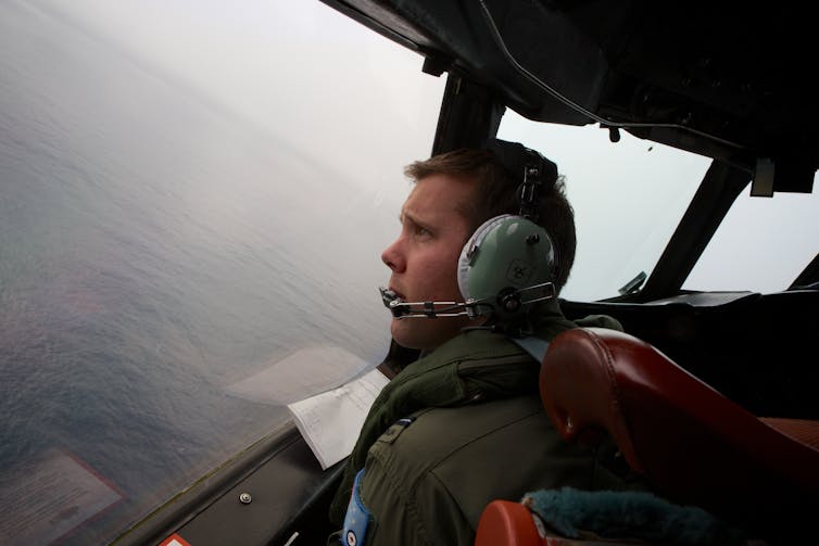
When actively searching for MH370, sophisticated international surveillance aircraft initially conducted over 300 flights to visually look for plane debris on the surface. Then surface and submersible vehicles conducted further surveys, searching over 120,000 sq km of ocean before ending the search in 2017.
The effort to find MH370 became one of the most expensive aviation searches in history. These surveys used both sonar(active acoustic instruments to image the sea floor to locate the aircraft), and also listening devices to pick up the aircraft’s flight data recorder.
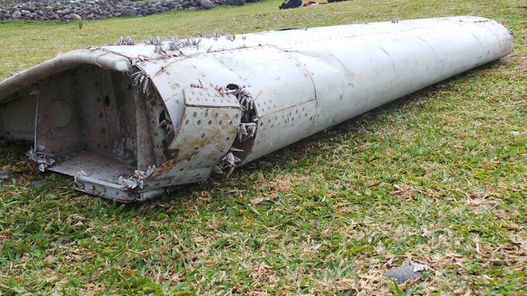
Confirmed MH370 plane debris were found on Reunion Island in July 2015, and off the coast of Mozambique in February 2016, which was consistent with what we know about ocean currents. In 2018, OceanInfinity, a private exploration company, also searched 25,000 sq km but without success.
Since then, a mixture of highly trained experts and members of the public have sought to assist the search. These efforts have varied from simple to really advanced data analysis. They have attempted to map the locations and timings of plane debris, and other maritime debris, as well as model drift currents. In doing so, they are attempting to reconstruct where these may have originated from, which is no small task.
Analysis of the MH370 flight path has been pieced together from two different types of radar – primary and secondary – as well as the intermittent data “pings” from the plane to the Inmarsatsatellite. The results suggest that it diverted south from its intended flight path.
Another technique called weak signal propagation (WSPR data (a way of using radio emission to track objects such as planes), had defined a specific but very large search area, some of which has already been searched.
Available hydroacoustic data (based on the way sound propagates in water) of the sea floor has also been analysed. However, only a relatively small area was covered and the marine sea floor in this region can be very rugged. There are deep submarine canyonsthat can hide objects much bigger than a plane.
Lessons from studying past flight disasters also informed the search. These included the 2009 Yemenia plane crash in the Indian Ocean.
Recovery operation
For inland or coastal water searches, a phased investigation strategy is suggested as best practice, where investigators look to identify water depths, major current strengths and directions, together with pre-existing site information, before specialist search teams are employed using methods, equipment configurations and personnel that have all been accredited.
However this reliance on technology can be problematic. Even in small waterways, the presence of vegetation in the search area or a target buried by sediment can make these searches difficult.
Much of the Southern Indian Ocean sea floor is rugged and relatively unmapped, with water depths of up to 7.4km. It’s away from regular shipping lanes and commercial flight patterns, with few fishing boats, no significant land masses and some of the worst winds and weather in the world. These factors also make it a very challenging area to search.
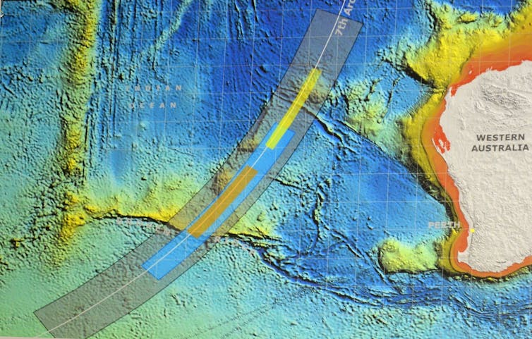
In deep water (more than 2km to 3km) deploying sonar is cumbersome and prohibitively expensive. It also takes a long time to generate data. A major challenge for scanning technologies is achieving accuracy at these kinds of depths due to the scattering of the signal caused by uneven, especially rocky substrates on the sea floor.
The development of more advanced autonomous submersible vehicles may hold the key to finding MH370 in the Southern Indian Ocean, along with post-processing of raw data which can clarify what can be attributed to rocks as well as sea-floor hummocks and pockets.
This can distinguish between the sea floor and the objects being searched for. However, the area where MH370 disappeared is vast, meaning future searches will remain just as challenging as when the plane first went missing in 2014.